The most detailed information about the water temperature in Tia Juana in The Caribbean (Venezuela). Forecast of changes in water temperature for the next 10 days. Statistics by months for recent years. Information about the neighboring resorts. Weather forecast in Tia Juana for a week.
Water temperature in Tia Juana right now
data updated 2 minutes ago81°F
yesterday: 81°F
a week ago: 83°F
Trend: stability
Today water temperature in Tia Juana is 81.7°F. It is very warm and comfortable water for long swimming in any body of water. It is believed that these are the ideal conditions under which one can be without the slightest discomfort. But it is worth remembering that at such a water temperature, various disease-causing organisms multiply very quickly. In any case, the general weather is also important. So, the air temperature at the same time will reach 86°F.
Analysis and forecast
The water temperature today is slightly lower than the average on this day in recent years. Its value has rise both over the past 20 days and over the past week. Exactly a year ago, on this day, the water temperature in this location was 84°F. Water temperature range in Tia Juana in April is from 78 to 87 degrees.
According to our forecast, in the next 5-6 days the water temperature in Tia Juana will become lower than today, but in 10 days it will still slightly rise, its value will be 82°F.
Table of water temperature values in Tia Juana
| Day | Fact* | Average** | Forecast*** |
| Apr 12 | 27.9°C | 29.3°C | |
| Apr 13 | 28.9°C | 29.5°C | |
| Apr 14 | 27.9°C | 29.5°C | |
| Apr 15 | 27.3°C | 28.3°C | |
| Apr 16 | 27.2°C | 29.0°C | |
| Apr 17 | 27.9°C | 29.3°C | |
| Apr 18 | 27.5°C | 29.0°C | |
| Apr 19 | 27.6°C | 29.0°C | |
| Apr 20 | 29.5°C | 28.1°C | |
| Apr 21 | 28.8°C | 27.4°C | |
| Apr 22 | 29.0°C | 27.6°C | |
| Apr 23 | 29.0°C | 27.6°C | |
| Apr 24 | 29.3°C | 27.9°C | |
| Apr 25 | 29.0°C | 27.6°C | |
| Apr 26 | 29.0°C | 27.6°C |
** Average - Average water temperature on this day in past years
*** Forecast - Our forecast for the water temperature
Actual nearshore temperatures may vary by several degrees from the indicated values. This is noticeable after heavy rain or after prolonged periods of strong winds. Some downstream winds cause cold, deep waters to replace surface waters that have been warmed by the sun.
To develop a forecast, we use our own mathematical model, which takes into account the current change in water temperature, historical data and the main weather trends, wind strength and direction, air temperature in each specific region. We also take into account data for other resorts in Venezuela.
Annual graph of average water temperature change in Tia Juana
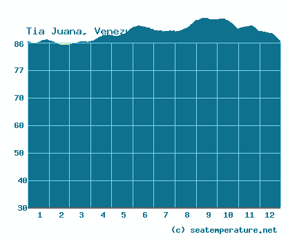
Water temperature in Tia Juana by month
Tia Juana located in the northern hemisphere, south of the northern tropic, at latitude 10 degrees. The swimming season in this location lasts all year round. Average annual water temperature on the coast in Tia Juana is 86°F, by the seasons: in winter 83°F, in spring 85°F, in summer 87°F, in autumn 88°F. Minimum water temperature (79°F) in Tia Juana it happens in February, maximum (91°F) in August.
You can find out detailed data on how the water temperature in Tia Juana changes in each specific month:
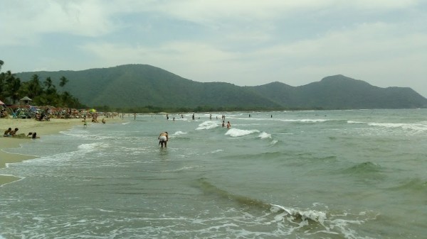
Tia Juana: general information and map
Neighboring cities and resorts
| City | Water* | Distance** |
| Cabimas | 82°C | 16km |
| Maracaibo | 80°C  | 53km |
| Sabaneta de Palmas | 81°C | 63km |
| El Toro | 82°C | 83km |
| Isla de Toas | 81°C | 84km |
| San Rafael de El Mojan | 81°C | 87km |
** Straight line distance in kilometers
The warmest water today in Venezuela recorded in Cabimas, its value is 82°F. Lowest - in Chacopata, there water temperature now 76°F. Average water temperature in the country today - 79°F.
Water temperature data in Tia Juana and neighboring towns and resorts collected from various sources, using buoys, using satellite maps of sea, river and lake surfaces of the NOAA agency.
We use data from various local authorities in each specific location of the world to more accurately reflect temperature values.
The nearest airport is located in a 9 kilometers. This is Oro Negro (CBS) airport. We have no information as to whether it is valid and what flights it receives or sends.
Tia Juana: weather forecast
The weather forecast is shown in local time in Tia Juana

 6km/h
6km/hhumidity: 66%, clouds: 72%

 9km/h
9km/hhumidity: 72%, clouds: 86%
 22km/h
humidity: 82%, clouds: 100%
16km/hhumidity: 83%, clouds: 100%
15km/hhumidity: 87%, clouds: 100%
 8km/h
8km/hhumidity: 83%, clouds: 85%
5km/hhumidity: 74%, clouds: 72%
11km/hhumidity: 68%, clouds: 79%
10km/hhumidity: 72%, clouds: 100%
11km/hhumidity: 87%, clouds: 100%
16km/hhumidity: 88%, clouds: 100%
9km/hhumidity: 87%, clouds: 95%
3km/hhumidity: 82%, clouds: 100%
 2km/h
2km/hhumidity: 77%, clouds: 100%

 6km/h
6km/hhumidity: 70%, clouds: 100%
7km/hhumidity: 68%, clouds: 100%
 3km/h
3km/hhumidity: 69%, clouds: 86%
8km/hhumidity: 72%, clouds: 79%
16km/hhumidity: 79%, clouds: 100%
3km/hhumidity: 81%, clouds: 95%
10km/hhumidity: 81%, clouds: 87%
14km/hhumidity: 79%, clouds: 93%
14km/hhumidity: 74%, clouds: 100%
9km/hhumidity: 67%, clouds: 100%
6km/hhumidity: 71%, clouds: 100%
8km/hhumidity: 79%, clouds: 98%
21km/hhumidity: 81%, clouds: 99%
14km/hhumidity: 87%, clouds: 99%
9km/hhumidity: 84%, clouds: 100%
13km/hhumidity: 81%, clouds: 100%
17km/hhumidity: 73%, clouds: 100%
9km/hhumidity: 71%, clouds: 100%
12km/hhumidity: 75%, clouds: 99%
7km/hhumidity: 76%, clouds: 99%
 16km/h
humidity: 75%, clouds: 48%
 12km/h
humidity: 83%, clouds: 58%
1km/hhumidity: 83%, clouds: 31%
6km/hhumidity: 80%, clouds: 65%